THE DEATH TOLL ROSE CONSIDERABLY OVERNIGHT, WITH 238 CONFIRMED DEAD AND AFTERSHOCKS CAUSING MANY WEAKENED BUILDINGS TO FALL.
THE ENTIRE COASTAL AREA IS DEVASTATED.
LANDSLIDES HAVE CLOSED SOME ROADS INTO THE AFFECTED AREA.
THE ENTIRE COASTAL AREA IS DEVASTATED.
LANDSLIDES HAVE CLOSED SOME ROADS INTO THE AFFECTED AREA.
Coastal areas nearest the epicenter were worst affected, especially Pedernales, a rustic tourist spot with beaches and palm trees, which appeared largely flattened.
Locals said children were trapped.
One man begged for help: "Pedernales is destroyed."
One man begged for help: "Pedernales is destroyed."
Enner Munoz, 40, a teacher from Pedernales,
said he was returning by car from a nearby locality and saw wooden
houses and lamp-posts collapse around him.
"It was devastating, all the roads are cracked open, there were two landslides," he said by phone, adding that bricks had landed in the bed of his home in Pedernales. His terrified family spent the night on the patio.
Though tsunami warnings were lifted, coastal residents were still urged to seek higher ground in case tides rise.
Authorities said there were 163 aftershocks, mainly in the Pedernales area.
A state of emergency was declared in six provinces.
ABOVE, VIDEO OF THE MOMENT THE LARGE EARTHQUAKE STRUCK, FILMED IN QUITO, ECUADOR, 100 MILES FROM THE EPICENTER.

FOLLOWING ON THE HEELS OF THE BIG JAPANESE QUAKES, THIS ONE IN ECUADOR MAY BE WORSE IN MANY WAYS.
AFTERSHOCKS IN THE 5.0 TO 6.0 RANGE HAVE BEEN REPORTED TODAY (SUNDAY, APRIL 17)..
LANDSLIDES HAVE NOW CLOSED SOME MAIN ROADS, MAKING RESCUE OF VICTIMS AND HELP FOR THE INJURED MORE DIFFICULT.
EXPERTS HAVE NOW RULED THAT THE ECUADORAN QUAKE WAS 20 TIMES THE STRENGTH OF THE RECENT 7.1 JAPANESE QUAKE.
The quake was the strongest to hit Ecuador since 1979,
"The temblor struck just before 7 p.m. local time (8 p.m. ET) with an epicenter 16 miles south-southeast of the coastal town of Muisne, located on the country's northwestern coast, the U.S. National Geological Survey said. The quake was recorded at a depth of about 12 miles.
The office of President Rafael Correa said early Sunday that the death toll had risen to 77, and 588 were injured. Correa earlier declared a national emergency.
The country's Geophysics Institute in a bulletin described "considerable damage" in the area of the epicenter and in Guayaquil. Vice President Jorge Glas said 10,000 military troops and 3,500 police have been dispatched to the affected areas.
The quake was strongly felt in country's capital of Quito, around 100 miles away.
NOAA's Pacific Tsunami Warning Center said tsunami waves up to 3 feet above tide level were possible for some coastal areas of Ecuador, but later said the threat had largely passed. Ecuador's president said those on the coasts should seek higher ground as a precaution. "
"In Manta, the airport was closed after the control tower collapsed, injuring an air force official.
Hydroelectric dams and oil pipelines in the OPEC-member nation were shut down as a precautionary measure.
At least 36 aftershocks followed, one as strong as 6 on the Richter scale, and authorities urged residents to brace for even stronger ones in the coming hours and days."
IN THE PAST 30 DAYS, ECUADOR HAS EXPERIENCED OVER 140 QUAKES.
INTERESTINGLY, ECUADOR'S MOST ACTIVE VOLCANO BEGAN ERUPTING VIOLENTLY 10 DAYS AGO...JUST AS JAPAN'S SAKURAJIMA BEGAN EXPLODING DAYS BEFORE THE MASSIVE QUAKES THERE.
"Tungurahua volcano (Ecuador): large explosion"
Pyroclastic flows (generated by partial column collapse) descended over 2000 m towards the Mandur and Achupashal areas.
The area is rich in corn fields which have been severely damaged by the ongoing eruption."
ELSEWHERE, GUATEMALA HAD A 6.1 EARTHQUAKE, TONGA EXPERIENCED A 5.8 QUAKE, A 5.7 OFF RUSSIA'S PACIFIC SHORE, A 5.4 IN THE EASTER ISLAND REGION, INDONESIA REGISTERED A 5.5 TEMBLOR, CHILE HAD A 5.4 QUAKE AS DID VANUATU AFTER A 6.4 THERE 3 DAYS AGO, JAPAN'S ALREADY DAMAGED AREA GOT SOME 5.0 AND ABOVE AFTERSHOCKS,.
ON APRIL 10, AFGHANISTAN RECORDED A 6.6 QUAKE
IN THE PAST 7 DAYS, THERE HAVE BEEN 147 GREATER THAN 4.5 MAGNITUDE QUAKES GLOBALLY.
THE USGS JUST RECORDED A FEW MOMENTS AGO A 5.6 AFTERSHOCK IN ECUADOR AND A 5.8 IN TONGA.
YELLOWSTONE, SUPER CALDERA, USA
RECENT WARNINGS BY SOME SCIENTISTS OF AN IMPENDING ERUPTION AT YELLOWSTONE CAUSED THE SEISMOGRAPHIC MONITORING SYSTEM THERE TO BE TAKEN OFFLINE AND THE ARCHIVES TO BE REMOVED SO THAT NO ONE PANICS OVER THE RECENT UPSWING OF SEISMIC ACTIVITY.
I MUST IMAGINE THEY DIDN'T REALIZE WHAT A BACKLASH THAT WOULD CAUSE?
FROM BENEATH THE VIDEO SHOWN ABOVE: "Mar 30, 2016
"Be
patient...it starts off dark (but I wanted that part to show so you
could see how it goes from black, to grey, to a super bright light show)..."
KEEP IN MIND THIS IS NIGHT (WATCH THE TIME IN THE LOWER RIGHT-HAND CORNER), EVEN THOUGH IT LOOKS LIKE DAYTIME.
THIS NIGHTTIME VIDEO IS EXACTLY THE OPPOSITE OF THE ONE ABOVE, WHICH STARTS OUT DARK AND GOES LIGHTER.
HOW ODD!
THIS NIGHTTIME VIDEO IS EXACTLY THE OPPOSITE OF THE ONE ABOVE, WHICH STARTS OUT DARK AND GOES LIGHTER.
HOW ODD!
A short documentary, and latest news clip of Yellowstone Super Volcano, at Yellowstone National Park USA.
UNNECESSARILY OVERLY DRAMATIC, IRRITATING NARRATION, BUT JUST A LOOK AT "WHAT IF?" BECAUSE IT PAYS TO BE PREPARED...EVEN IF THIS NEVER HAPPENS.
THERE IS SOME VALID HISTORICAL INFORMATION THERE AS WELL.
UNNECESSARILY OVERLY DRAMATIC, IRRITATING NARRATION, BUT JUST A LOOK AT "WHAT IF?" BECAUSE IT PAYS TO BE PREPARED...EVEN IF THIS NEVER HAPPENS.
THERE IS SOME VALID HISTORICAL INFORMATION THERE AS WELL.
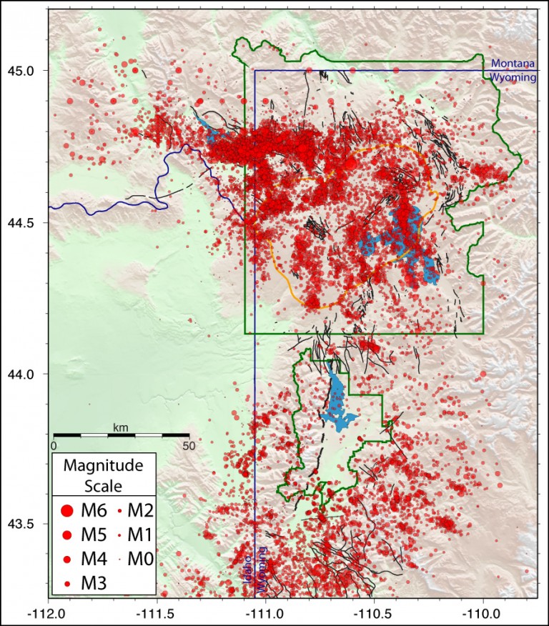
ABOVE, A RECENT SEISMIC ACTIVITY MAP OF THE YELLOWSTONE AREA, from the website :
http://www.geoengineeringwatch.org/yellowstone-public-seismographs-taken-off-line/
Yes, that might "panic" some, but we ALL need to know all we can about such things, don't we?
PACIFIC NORTHWEST FRAUGHT WITH VOLCANIC HAZARDS
WE ALL ARE AWARE OF THE MOUNT ST. HELENS ERUPTIONS, BUT NOT SO MANY ARE AWARE OF THE MANY VOLCANOES IN THAT AREA DEEMED "ACTIVE BUT DORMANT"...
MT. RAINIER
"At some point and time it will decide it wants to erupt," said Schroedel.
"Mt. Rainier Lahar warning areas include, Pierce, Lewis, and Thurston Counties, but depending on the blast could reach parts of King County. Father north in Snohomish County, scientists are keeping a watchful eye on another volcano.
GLACIER PEAK
"With its history of explosive eruptions, it turns out to be a really important volcano," said U.S.G.S. Geologist Dave Ramsey.

Earthquakes, even busy "swarms", at volcanoes are usually not a sign of an impending eruption, but together with other observations (deformation, gas emission, temperature changes) they provide one important and early clue when eruptions may be approaching.
Volcano seismologists track not only earthquakes, but also various kinds of seismic signals with special characteristics that suggest magma movement.
A special challenge at Cascade volcanoes is seismic activity associated with glacier movement, icefalls, and rockfalls—these are the most common signals we see! Distinguishing between all the different types of seismic sources can be difficult: a job for a specialist.
JUST AS MASSIVE AS YELLOWSTONE, BUT UNKNOWN TO MOST AMERICANS, THE VALLES CALDERA, NEW MEXICO, WHICH LIES VERY CLOSE TO THE LOS ALAMOS SITE.
"Although many people have heard of Yellowstone or Long Valley, the Valles caldera in New Mexico is just as impressive as either of these behemoths. This caldera is part of a chain of geologically-young (less than 5 million years old) volcanic rocks across the Jemez Mountains. Valles had one of the largest known explosive eruptions in the last few million years: the famed Bandelier Tuff, which erupted ~1.25 million years ago and spread over 300 cubic kilometers of ash and volcanic debris over the Southwest. Since that massive eruption, smaller domes have formed, some as recently as ~40,000 years ago. It is new domes like these that are the most likely future activity (if any) at the Valles caldera."

VALLES CALDERA
169 'ACTIVE' VOLCANOES
There are about 169 volcanoes in the United States that scientists consider active.
HOW MANY KNEW VOLCANOES EXIST IN ARIZONA, COLORADO, MISSISSIPPI, MISSOURI, NEW HAMPSHIRE, TEXAS AND VIRGINIA?
THEY'RE THERE.
THE LARGEST EARTHQUAKE TO EVER HIT AMERICA WAS NEAR THE MISSISSIPPI RIVER, IN MISSOURI, NOT OUT WEST.
"The New Madrid earthquakes were the biggest earthquakes in American history. They occurred in the central Mississippi Valley, but were felt as far away as New York City, Boston, Montreal, and Washington D.C. President James Madison and his wife Dolly felt them in the White House. The tremors rang church bells in Boston.
From December 16, 1811 through March of 1812 there were over 2,000 earthquakes in the central Midwest, and between 6,000-10,000 earthquakes in the Bootheel of Missouri where New Madrid is located near the junction of the Ohio and Mississippi Rivers.
In the known history of the world, no other earthquakes have lasted so long or produced so much evidence of damage as the New Madrid earthquakes.
Three of the earthquakes are on the list of America’s top earthquakes: the first one on December 16, 1811, a magnitude of 8.1 on the Richter scale; the second on January 23, 1812, at 7.8; and the third on February 7, 1812, at as much as 8.8 magnitude.
SCIENTISTS SAY THE NEW MADRID FAULT IS "PAST DUE" FOR ANOTHER MAJOR QUAKE.
WE LEARN ABOUT THESE THINGS SO WE CAN FORMULATE PLANS OF ACTION TO THE BEST OF OUR ABILITY.
AS ALWAYS, I MAINTAIN THAT KNOWLEDGE ERASES FEAR.
WE FEAR MOST WHAT WE DON'T UNDERSTAND.
I HOPE THIS BLOG ARTICLE HAS CREATED A BETTER UNDERSTANDING OF SEISMIC EVENTS...AND WHAT WE CAN DO TO PREPARE FOR ANYTHING.
No comments:
Post a Comment